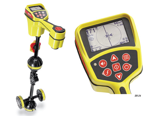
Technology is rapidly improving the way we do almost everything and utility line location is no exception. The new Ridgid SR-24 ($2634) will be launching shortly and features many of the features of the SR-20 ($2295) however the new unit will be able to sync with Ridgidtrax app (free) on your phone to plot the exact location. While we have downloaded the app we have not seen it in action because without the SR-24 it doesn’t do much good. More information will be coming shortly and of course you can order it from Ohio Power Tool 800-242-4424 as soon as it becomes available. Some additional stats on the SR-24 from Ridgid below:
Three Ways to Use Ridgid SR-24 for Mapping:
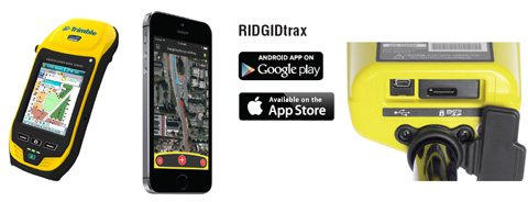
1. Wirelessly Stream locating data to common Bluetooth® compatible GPS devices including offerings from Trimble® and Leica®.
2. Download the RIDGIDtrax App for your mobile phone or tablet and wirelessly stream locating and GPS data from the SR-24 to your device via Bluetooth®. With RIDIGDtrax, a user can select the type of utility being traced (water, gas, electric, etc.) and display depth and GPS position on a real-time map. A finished map can be saved and viewed inside the app or exported to a *.KML file for use with popular GIS programs such as Google Earth™.
3. Insert a microSD™ card into the SR-24 and log both locating and GPS data streams to the card.
BENEFITS
• Large display shows the utility’s estimated position, direction, and depth
• Omnidirectional antennas capture the complete signal field for greater speed and accuracy
• Built-In GPS track location coordinates for mapping and GIS applications
• Bluetooth® technology stream data to smartphones, tablets, or high-precision GPS instruments
• Smartphone/Tablet App map multiple tracks and waypoints and export to GIS software
SPECIFICATIONS
• Weight (without Batteries)….3.3 lb (1.5 kg)
• Length……………………………..11.2″ (28.4 cm)
• Width………………………………4.3″ (10.9 cm)
• Height……………………………..31″ (79 cm)
• Battery Type……………………..4x Size C, 1.5 V Alkaline, 1.2 V NiMH/NiCad
• Operating Temperature………-4°F to 122°F (-20°C to 50°C)
• Storage Temperature…………-4°F to 140°F (-20°C to 60°C)
• Programmable Line & Sonde Frequencies…………….Any from 10 Hz to 35 kHz
• Default Active Line Trace Frequencies……………..128Hz, 1kHz, 8kHz, 33kHz
• Passive Power Frequencies………………………50Hz, 60Hz
• Passive Frequency Ranges…………………………….<4kHz, 4kHz – 15kHz, 15kHz – 30kHz
• Programmable Line Trace Frequencies……………..Up to 35kHz
• Sonde Frequencies…………….16Hz, 512Hz, 33kHz
• Wireless Technology………….Bluetooth® Class 1
• Wireless Range…………………1093 yards (1000 meters)
• GPS Average Accuracy………Less than 2.5 m (8.2 ft)